Long version (with photos) follows:
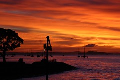 I was up at O'Dark-Thirty to catch the ferry out to Motutapu. Weather was looking perfect and there was a nice sunrise going at Devonport Wharf. I'd arrived quite early, so I hit the cafe. There I just happened to run into my friend Derek. He was headed over to Auckland to sail in a regatta. He was on the yacht Thelma, racing around Rangitoto island but I only ended up seeing the regatta from quite a long ways away.
 Note to self: Pain Au Chocolat + Large Coffee = excellent pre-race breakfast! :-)
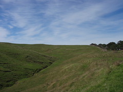
 It's about a 30 minute ride out to Motutapu, so I wandered around the boat taking some photos of the Auckland skyline on the way out. Auckland from that angle is mainly containers and cargo cranes, so nothing worth posting there. There were a couple nice views of Rangitoto on the way in. This shot gives a good idea of the scale of the volcano. The race course runs just around the peak.
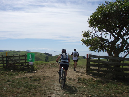
 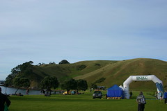 Once we landed on Motutapu, I put my race gear together, stashed the rest, and had a wander around the race HQ. I ran into a few more friends from work while waiting for the start. Speaking of which, in this photo, the start of the course runs straight up that hill in the draw just to the left of the inflatable arch. :-(
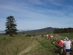 The start of the race was quite packed. It was pretty much a solid mass of people walking up that first hill bit. Given the off-road course, I certainly wasn't planning on setting any PR's, so I just settled in and went with the flow. I managed to snap quite a few pictures through this stretch. In this one you can see Rangitoto out on the horizon. From where we are (about 2km into the course), we go over onto Rangitoto Island, straight up the hill, around the edge of the peak/crater, and back.
  The first 8 k's or so were all mown grass truck trail through rolling pastures. The instant we crossed over onto Rangitoto island things changed dramatically. We were now running on a road of pulverized lava rock running through a field of not-so-pulverized lava rock. It was quite a long steady climb up to the shoulder of the peak.
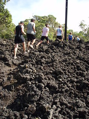 Just after the highest point on the course, we dove into a bunch of lava rock singletrack through the bush. This stuff was extremely technical. People piled up a bit again as there was no way to pass. I was happy just cruising along, but my heartrate recovered quite a bit from the big climb at the pace we were going. Every now and then the trail would widen a bit and people would get a little crazy. I saw one guy take a tumble just ahead of me. He stuck his hands out to catch his fall and got absolutely shredded by the lava rock. I stopped to see what I could do, but he had some friends with him so they sent us along.
 I got back to running thinking "Damn, I'm glad I know how to fall." About 5k later, the trail turned back into sort of a road. We were at about the 10k mark and I'd hardly been running, so I picked up the pace quite a lot. Sure enough, at some point I kicked a big tumbling hunk of lava rock and went down. I did a nice shoulder roll, so I took only a couple tiny scratches on my lead hand and a small tap on my elbow, but I must have come up with my weight on one knee because I ended up with a nice hunk of rocked stabbed into my leg just below the knee. I took a couple jogging steps and didn't feel any problems, so I stopped and pulled the rock bits out of my leg. There was a big bloody hole that I couldn't see the bottom of, but not that much was coming out, so I figured I'd be fine to keep going.
My knee felt quite bashed at first, but it warmed up in a minute or two. A kilometer or so later there was a water stop, I chucked a cup of water on the cut and had a look at it. I thought "Oooh, that's not good" but again, the bleeding was surprisingly light, and it didn't hurt to run on, so I thought I might as well keep going. It would probably take just as long to sit down and wait for an ATV evac, not to mention I'd be tying up the ATV that somebody else might seriously need. After that I didn't think about much of anything other than exactly where every footstep was going.
 After quite a long stretch of lava rock singletrack segments, I was breathing a sigh of relief to be off Rangitoto and back in the rolling pastures of Motutapu. I didn't even mind the massive gradual uphill. It was actually kind of fun passing up mountain bikers slogging along in their granny gears.
 B.t.w. I love how you can see people strung out all along the horizon in this photo. Though it kinda sucks that they're all ahead of me . . . I suppose that's the price of an extremely careful 7 or 8 k's through the last of the lava rock.
This was my favorite photo of the day . . . and not just because I'm almost done with the race . . .
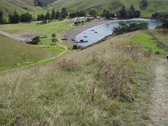 This was the view from just the other side of the signpost in the last picture. The last K was pretty much a dive bomb run to the beach. Over the last few k's I'd spotted my friends from work, so I'd been chasing them a bit. I didn't catch them, but they were still gathered up at the finish when I came through.
 I drank my sports drink and ate a banana while I chatted with them for a bit, then decided I'd better go see the ambulance guys. They dribbled some sterile water on my leg and said I should probably visit an A&E to have them "whack a few stitches in it". Well yeah, no kidding. ;-)
Ah well, I'm not sure what I was expecting, probably best that they saved their sterile water for dehydration IV use, and no sense bandaging a dirty wound that's clotted up and stopped bleeding.
So I went down to the beach, jumped in the ocean and scrubbed out the wound myself with seawater. :-) I still really didn't like what I saw, but there wasn't anything more to be done about it in the field.
After that I hung out for the after race festivities: lamb burgers, beers, merit prizes, and watching the rest of the racers come in. Ferry's were coming in every half hour or so starting at 1:30 or so, but the queues were really long, so we sat around until about 3pm before we decided to go join the queue. At that point it was pretty clear that there were some logistical issues with the ferry schedule, but we all got off the island by about 5pm.
On the way home I stopped at a pharmacy and grabbed a bunch of supplies, including some steri-strips (3M adhesive stitches). It's been over 72 hours now, the steri-strips are holding nicely, and the leg wound is looking ok. Or at least better than the other minor injuries, which are being treated with my usual regimen of total neglect. So score one for the healing power of seawater. ;-)
Note: stuff to pack in a real first aid kit for Adventure Racing:
- Good squirt bottle with clean water.
- Green scrubby pads (still sealed)
- Liquid Antiseptic
- Antibiotic cream
- Big gauze pads
- Steri Strips
- Athletic/Duct Tape
But the bottom line is: despite another clumsy injury, it was a great day and a nice workout on an excellent course.
Here the NZ Herald write-up of the event:
Multisport: Scenic Dual attracts full field
And a promotional video from the Organizers (TotalSport.co.nz):
http://www.totalsport.co.nz/video.html
Technical note: I had tried a little experiment with my iPhone during the race. I'd downloaded an app called RunKeeper that acts as a little GPS waypoint recorder. Unfortunately, due to iPhone OS limitations, you can't use the hard screen lock while it's running, or it will stop recording. It has it's own soft lock, so at the race start, I started recording, locked it, and chucked it into the hip pocket on my hydro-pack. Somewhere around the halfway point in the race it seems that my gel-packs in that same pocket warmed up enough to start triggering the touch screen. They seem to have unlocked the screen, exited the app, made 4 phone calls to a 6-digit (fortunately nonexistent) number. They then proceeded to start a new text message and type lots of random keystrokes into it for over an hour. I'm very lucky that was never sent, that would have divided into hundreds of parts. As it was it drained the battery, and took 10 minutes to delete! I'll have to grab a little hard case for the iPhone before trying that again. :-)
Anyway, I mention that because I was hoping to have a map of the route here. Instead here's a plain Google maps view of the two islands. Crude route is Home Bay -> connection to Rangitoto -> Straight up the hill to the volcano's cone -> round the peak and down to Rangitoto wharf -> along the shore back to the Motutapu connection -> back across the pastures to Home Bay.
There's a detailed map on the website if you're really interested. There's some cool stuff on the islands, I wouldn't mind getting back out there sometime soon to check out the WWII fortifications, the volcanic crater at the very top, and the old lava tube caves.
View Larger Map
Rob
ReplyDeleteGreat Dual blog, lava fields photo has brought tears to my eyes......again!!! Great day though.
Cheers
Andrew Trust
Thanks! Yeah, it was a great day wasn't it! I'd definitely do that one again!
ReplyDelete